🌍 1. Introduction to Sir Bani Yas Island Map
The Sir Bani Yas Island map serves as a key navigational tool for travelers exploring this spectacular eco-tourism destination in Abu Dhabi. Situated about 170 kilometers southwest of the UAE capital, Sir Bani Yas Island is a natural sanctuary known for its rich biodiversity, luxurious resorts, and adventure-filled landscapes. Established by the late Sheikh Zayed bin Sultan Al Nahyan, the island is home to the Arabian Wildlife Park, archaeological sites, and a pristine coastline that captivates visitors from around the world.
Understanding the Sir Bani Yas Island map allows tourists to plan their journey efficiently, from ferry terminals to resort locations, wildlife viewing areas, and water activity zones. Whether you’re a nature lover, historian, or adventure seeker, the Sir Bani Yas Island map helps you uncover every hidden gem of this tranquil paradise.
📍 2. Location and Accessibility of Sir Bani Yas Island
The Sir Bani Yas Island map clearly outlines its strategic location off the western coast of Abu Dhabi. The island lies in the Al Dhafra region of the Emirate, approximately 8 kilometers offshore from Jebel Dhanna. Travelers can reach the island by road, air, or sea, depending on their preference.
- By Road and Ferry: From Abu Dhabi city, it takes around 2.5 hours by car to reach the Jebel Dhanna Jetty, from where ferries and private boats operate regular transfers to Sir Bani Yas Island.
- By Air: Some luxury resorts on the island offer private chartered flights or seaplane services from Abu Dhabi and Dubai.
- By Tour Operators: Several travel agencies provide organized day trips and overnight stays, often including transportation and guided experiences based on the Sir Bani Yas Island map.
Using the Sir Bani Yas Island map before travel helps you visualize routes and plan timing efficiently for a seamless journey.
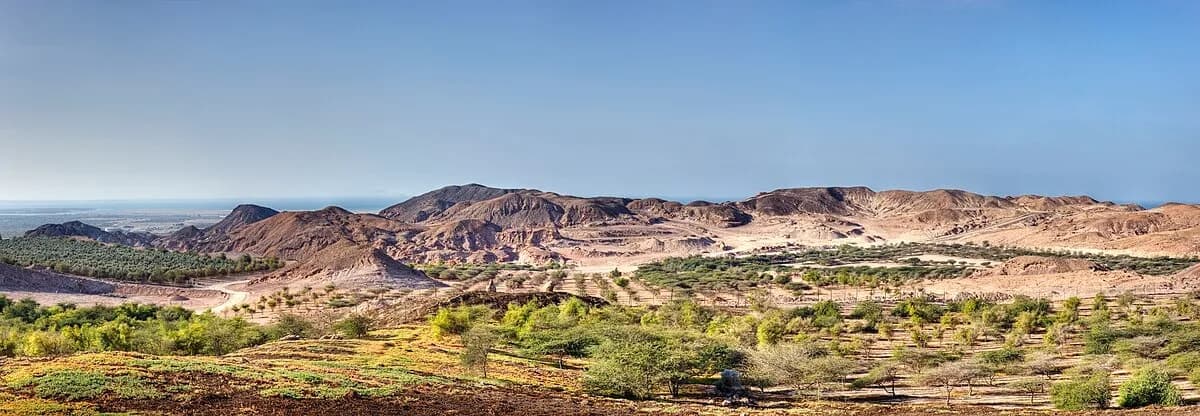
🗺️ 3. Understanding the Sir Bani Yas Island Map Layout
When exploring the Sir Bani Yas Island, visitors can identify distinct zones designed for different experiences — from wildlife reserves to luxury retreats and historical landmarks.
Key areas on the Sir Bani Yas Island map include:
- Arabian Wildlife Park: Covering over half the island, this protected area is home to more than 17,000 free-roaming animals such as gazelles, giraffes, and cheetahs.
- Luxury Resorts: The Anantara Resorts complex (Desert Islands, Al Yamm, and Al Sahel) is clearly marked on the Sir Bani Yas Island map, each offering unique landscapes — beachfront, savannah, or desert.
- Adventure Zones: Areas for kayaking, hiking, and mountain biking are pinpointed for tourists seeking adrenaline-filled experiences.
- Cultural Sites: Ancient Christian monastery ruins and archaeological sites dating back to 600 AD are marked for history enthusiasts.
Studying the Sir Bani Yas Island before your trip ensures you maximize your time while uncovering all attractions efficiently.
🐾 4. Wildlife Encounters and Nature Trails
The Sir Bani Yas Island map showcases expansive zones of the Arabian Wildlife Park — a remarkable conservation area where animals roam freely in a natural environment. Jeep safaris and guided eco-tours help visitors explore these wildlife habitats responsibly.
Animals you’ll find according to the Sir Bani Yas Island include:
- Arabian Oryx
- Somali Ostriches
- Giraffes
- Gazelles
- Cheetahs
Each wildlife zone on the Sir Bani Yas Island map is designed for minimal human interference, ensuring sustainable eco-tourism. Several walking and cycling trails pass through scenic viewpoints, mangrove forests, and hilly terrain, allowing visitors to connect closely with nature.
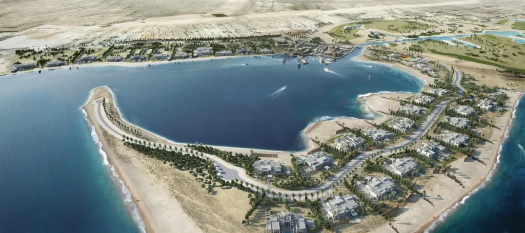
🏖️ 5. Resorts and Accommodation Zones on the Island
The Sir Bani Yas Island map highlights a variety of accommodation zones suitable for different types of travelers. The island’s resorts combine modern luxury with authentic Arabian aesthetics, providing a peaceful stay amidst untouched natural beauty.
Highlighted stays on the Sir Bani Yas Island include:
- Anantara Desert Islands Resort & Spa: Located near the island’s northern coast, offering panoramic sea views.
- Anantara Al Yamm Villa Resort: Nestled along the eastern shore, ideal for beach lovers and water sports enthusiasts.
- Anantara Al Sahel Villa Resort: Found within the savannah region of the island, surrounded by wildlife.
Each property offers direct access to scenic routes and activities listed on the Sir Bani Yas Island, ensuring guests can explore comfortably.

🧭 6. Adventure Activities and Outdoor Exploration
The Sir Bani Yas Island map features several adventure routes that cater to thrill-seekers and explorers. From rugged mountain trails to serene lagoons, the island promises memorable experiences.
Top adventures marked on the Sir Bani Yas Island map:
- Kayaking through Mangroves: Paddle across natural waterways teeming with marine life.
- Mountain Biking Trails: Routes mapped along scenic ridges and valleys.
- Horseback Riding: Trails that weave through open savannahs.
- Snorkeling and Diving: Coastal zones marked for underwater exploration.
- Guided Nature Hikes: Walking trails leading to scenic viewpoints and archaeological discoveries.
Every route is carefully documented on the Sir Bani Yas Island map, helping visitors choose paths suited to their experience level.
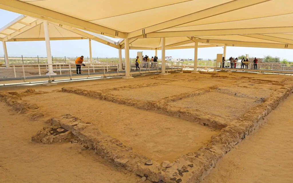
🕌 7. Cultural Heritage and Historical Insights
Beyond nature and luxury, the Sir Bani Yas Island map directs visitors to significant cultural and historical landmarks. The island is home to the UAE’s only discovered Christian monastery, believed to date back to the 7th century. Excavated areas are open for exploration, and interpretive signs provide historical context.
Archaeological findings visible on the Sir Bani Yas Island map reveal the island’s ancient trade connections and its role in regional maritime history. Heritage walks and guided cultural tours are organized to help visitors connect with this rich legacy.
🧳 8. Travel Tips for Visiting Sir Bani Yas Island
To make the most of your experience using the Sir Bani Yas Island map, consider the following expert travel tips:
✅ Best Time to Visit: October to April, when the weather is pleasant and suitable for outdoor exploration.
✅ Booking in Advance: Accommodation and ferry seats are limited, so pre-booking is essential.
✅ Respect Wildlife: Follow safety instructions and maintain distance from animals within the Arabian Wildlife Park.
✅ Use Official Maps: Always refer to the latest Sir Bani Yas Island map versions provided by Anantara or Abu Dhabi’s Department of Culture and Tourism for accurate routes.
✅ Bring Essentials: Sunscreen, hats, binoculars, and comfortable shoes are must-haves.
These tips ensure a smooth, enriching experience as you navigate the Sir Bani Yas Island map.
🌅 Conclusion: Why the Sir Bani Yas Island Map Is Essential for Every Traveler
In conclusion, the Sir Bani Yas Island map is more than just a guide — it’s the ultimate key to unlocking the island’s wonders. From wildlife adventures and luxury resorts to cultural treasures, every aspect of this island paradise is best experienced with an understanding of its geography.
By using the Sir Bani Yas Island map, travelers can plan efficient routes, uncover hidden attractions, and appreciate the true essence of Abu Dhabi’s most breathtaking island destination. Whether you’re visiting for relaxation, adventure, or cultural exploration, this detailed Sir Bani Yas Island map ensures you experience the best of everything Sir Bani Yas has to offer in 2025.
🔗 External Links for Further Reference
Also Read: Popular Walking and Cycling Trails in Sir Bani Yas Island – 2025 Adventure Guide